Comments (11)
 hannesj
commented on May 28, 2024
2
hannesj
commented on May 28, 2024
2
I'm not that concerned with trip planning aspects, but more so with other aspects of passenger information, such as departure boards, online/printed timetables etc, which rely on a single stop id being used cosistently. I think that each physical stop should be represented with an unique identifier inside a feed, and its usage should be mandated everywhere.
I do not understand the concern of deep loops, as at least with location groups, as they were called previously, could only reference either stops or locations, not other location groups. That way there could never be any nesting. I'm not sure if this was overlooked when going from using separate groups to the areas.txt from fares-v2.
An example stop that would be affected is https://www.ostgotatrafiken.se/hallplats/bergslagstorget which is served by regular lines 181 and 182, as fell as flexible services FI01-FI08, which all cover an area and up to five stops.
from transit.
 leonardehrenfried
commented on May 28, 2024
1
leonardehrenfried
commented on May 28, 2024
1
But doesn't that diagramm just show a well connected graph? Sure, you can do silly things that will be hard/impossible to compute but isn't that the responsibility of the producer?
If you have stop areas that may make computing fares ambigious, should you not create a separate area one just for the flex service?
Edit: Now that I said it "shifting responsibility to the producer" is probably asking for trouble.
from transit.
 bdferris-v2
commented on May 28, 2024
1
bdferris-v2
commented on May 28, 2024
1
@westontrillium to your point, I think there is plenty of precedent for making changes to the spec that generally break backwards compatibility for feed consumers (as opposed to feed producers), though of course, we try to avoid it if we can. But GTFS-Flex is going to be one giant breaking change for feed consumers no matter how you slice it :)
To your specific point, there is precedent for changing an existing Required field to "Conditionally Required" if we can define a reasonable condition. And having an area_id or location_id specified could reasonably be that condition.
from transit.
 westontrillium
commented on May 28, 2024
westontrillium
commented on May 28, 2024
Someone from Transit should confirm. I believe part of their concern was situations where "stopB" is doing all of this:
@hannesj Do you think it could be worth discussing the possibility of reverting back to something (exactly?) like location_groups.txt to describe stop collections, minus polygons? The original justification for switching to areas.txt/stop_areas.txt to describe groups of flexible zones/stops was that those files were already part of Fares v2 and offered the same functionality as location_groups.txt.
from transit.
westontrillium
commented on May 28, 2024
From a producer point of view, the geojson feature alternative gives me pause just because we'd also need to deal with points that exist in stops.txt and geojson features. I'm also not sure we want to start representing stops data in a file other than stops.txt.
It would be possible to use GeometryCollections instead of MultiPoint to allow for each point of a collection of stops to refer to a stop_id to capture metadata like stop_name/code, but then you're still having to refer to several files (stop_times>locations.geojson>stops versus stop_times>areas>stop_areas*>stops).
Instead of a foreign key relationship, you could just add stop_name/stop_code fields to each feature in the GeometryCollection, but it just seems strange to me to reconstruct data that already exists elsewhere instead of just referencing it.
Either of these solutions are more burdensome for a producer than what is already in the spec.
*A location_groups equivalent would be one less step, for what it's worth.
from transit.
 npaun
commented on May 28, 2024
npaun
commented on May 28, 2024
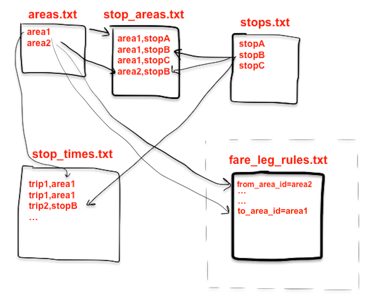
Let me try to draw @westontrillium's diagram in separate stages, to illustrate our concern with the current implementation of location groups and polygonal stops.
Existing GTFS features
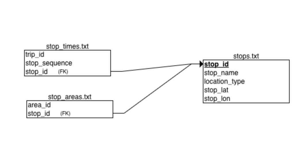
stop_areas.stop_id and stop_times.stop_id are foreign keys referencing stops.txt, and one would have the expectation that all fields named stop_id relate to to stops.txt in some way.
Current state of GTFS Flex proposal

Things have gotten a bit complicated:
stop_times.stop_idis now a special type of key referring to eitherstops.stop_idorstop_areas.area_idor theidof aFeatureinlocations.geojson.stop_areas.stop_idnow refers to eitherstops.stop_idor a Feature'sid. (Maybe it could also refer tostop_areas.area_idfor consistency withstop_times.stop_id- but now we have a cyclic data structure.... errrh...)- Some other fields like say
stops.parent_stationortransfer.from_stop_idcontinue to refer only tostops.txt? Not sure.
Also, we've duplicated certain fields like stops.stop_name and a Feature's stop_name.
Transit's proposal

- We propose that the foreign key relation to
stops.txtbe preserved. - A new
location_type=5is introduced for Flex areas (final name TBD).- If
location_type=5thenstops.location_idis conditionally required, and refers to a Feature'sid. stops.stop_latandstops.stop_lonare conditionally forbidden. These fields are already optional for some location_types so it isn't a breaking change.
- If
- Metadata is removed from
locations.geojson, sostops.stop_nameis the only place to name a stop, for example. - Features could have
MultiPolygongeometry (for service areas), orMultiPointgoemetry (to replace location groups)
Outstanding issues
- For MultiPolygon, we believe our proposal neatly solves a lot of difficult to implement parts of the existing spec.
- Unfortunately, for
MultiPoint(location groups), it introduces problems of its own: the members of location groups aren'tstopsand don't have their own metadata anymore.- We can allow a limited amount of metadata by treating location groups as
GeometryCollections.
- We can allow a limited amount of metadata by treating location groups as
- At this point we turn to y'all for input. Together, can we brainstorm a way to handle location groups with minimal complexity?
from transit.
westontrillium
commented on May 28, 2024
I understand the desire to simplify referencing, but I really do not like idea of needing to maintain identical data for single stops in two different places (locations.geojson and stops.txt). Thinking of some alternatives to weigh this against...
Just triple checking an assumption I've had, is there really no precedent for changing a column in the spec from "Required" to "Conditionally Required", or is that truly not considered a backwards-compatible change? Flex already changes the Conditional Requirement of arrival_time: "- Required for the first and last stop in a trip (defined by stop_times.stop_sequence)"...
Because if we could do that to stop_times.stop_id, that could solve the issue of it referencing stop_id, location id, or area_id. Instead, we could have new columns in stop_times for directly referencing a location id or area_id (location_group_id, or whatever), and that record could exclude the now conditionally required stop_times.stop_id. This is what I believe @flocsy touched on in reviewing the Flex PR.
I hesitate to include this, as it's thinking waaay outside the box (I'm trying everything here!), but if we can't get around the required stop_times.stop_id, would it be possible to add an "array" type column to stops.txt to have a stops.txt record reference multiple stop_ids as a "stop group?" The individual column could have its "arrayed" values separated by a space, a pipe, or even be in a JSON-like bracketed array format. So you would have in stops.txt:
| stop_id | location_type | stop_group_array |
|---|---|---|
| group1 | 5 [or 6] | stopA stopB stopD stopG |
Then in stop_times.txt:
| trip_id | stop_id | stop_sequence |
|---|---|---|
| weekday | group1 | 1 |
Fully acknowledging this is highly unorthodox and likely an impossibility. At the very least, it was a good thought exercise for me :)
from transit.
npaun
commented on May 28, 2024
Those are both interesting ideas, @westontrillium.
stop_times.area_id
Off the top of my head, I think this would be a valid approach. I'd need to think about this more with my team though.
location_type=6
We can mechanically transform stop_group_array into a single-valued column (see the diagram below), if we want to avoid introducing new data types. How do you feel about the result --is it something worth thinking about further?

from transit.
leonardehrenfried
commented on May 28, 2024
I like the direction that this discussion is taking. I've long felt that the foreign key relationships (or lack thereof) where not as "tight" as they could be, but couldn't actually put my finger on it. Keeping all data other than the actual geometry in stops.txt is a good move to me.
I think new location_types are a good idea and thought about this previously. I don't think it's technically required but it will probably be very useful for consumers who have never heard of flex and gives them something to Google.
However, I think that using MultiPoints or any other collection types in locations.geojson is a bad idea. So is introducing a a collection column.
If you don't want to lump stop_areas and location groups together I would prefer going back to an explicit location_groups.txt.
from transit.
westontrillium
commented on May 28, 2024
At this point, it looks like we're discussing two distinct options, yes?
- Add
stop_times.location_idandstop_times.location*_group_idcolumns, makestop_times.stop_idconditionally required. stop_times.txt still directly references locations.geojson and location_groups.txt, but each have their own foreign key column in stop_times.txt. - Add a
stops.location_type=5andstops.location_type=6for GeoJSON Polygons/MultiPolygons and location groups, respectively, addstops.location_idandstops.location_group_idcolumns which references an associated locations.geojson or location_groups.txt value.stop_times.stop_idcan reference astop_idthat in turn references alocation_idorlocation_group_id.
As a producer, I prefer Option 1, as it is much simpler to implement. Option 2 has more reference steps, requires creating more data (since you'd need to generate a stops.txt entry for each location/location group), and is more burdensome to maintain longterm due to the requirement of sustaining parity between a record's metadata in stops.txt and its locations.geojson/location_group data. These issues would be compounded for smaller producers.
*If this is amended to only refer to stops, should the name change to something else, or do we leave the potential to be able to include other location types later...?
from transit.
Related Issues (20)
- Add rider_category_id to fare_products.txt
- Add maximum waiting time to transfers.txt HOT 2
- Documentation: inconsistencies between gtfs-realtime.proto
- GTFS-Fares v2: Improvement of filling with stops of a certain area HOT 3
- Move Dataset Publishing and General Practices from Best Practices to the spec HOT 12
- Add recommended presence: reconciling confusion between best practices and spec HOT 10
- Thoughts on forbidding "subfolder inside zip"? HOT 8
- TripDescriptor.start_date matching between GTFS-RT + GTFS-static HOT 2
- GTFS-Flex: Service Discovery HOT 11
- Add rule_priority field to fare_leg_rules.txt HOT 7
- Add fare_media_type=1 to fare_media.txt HOT 8
- GTFS-Fares v2: Add networks.txt & route_networks.txt HOT 13
- GeoJSON in GTFS? (Or the future of GTFS serialisation) HOT 20
- Phone number international format in GTFS HOT 2
- stop_times.shapes_dist_traveled shouldn't be defined if the trip doesn't have shapes associated HOT 7
- GTFS changes - voting agents HOT 12
- Moving Schedule Best Practices into the Spec: Phasing Plan HOT 5
- [GTFS-Flex] Remove referencing location.geojson ids in stop_areas.txt (formerly location_groups.txt)? HOT 1
- GTFS-fares v2: Fare Leg Rule "Scope" Support
Recommend Projects
-
 React
React
A declarative, efficient, and flexible JavaScript library for building user interfaces.
-
Vue.js
🖖 Vue.js is a progressive, incrementally-adoptable JavaScript framework for building UI on the web.
-
 Typescript
TypeScript is a superset of JavaScript that compiles to clean JavaScript output.
-
TensorFlow
An Open Source Machine Learning Framework for Everyone
-
Django
The Web framework for perfectionists with deadlines.
-
 Laravel
A PHP framework for web artisans
-
D3
Bring data to life with SVG, Canvas and HTML. 📊📈🎉
-
Recommend Topics
-
javascript
JavaScript (JS) is a lightweight interpreted programming language with first-class functions.
-
web
Some thing interesting about web. New door for the world.
-
server
A server is a program made to process requests and deliver data to clients.
-
Machine learning
Machine learning is a way of modeling and interpreting data that allows a piece of software to respond intelligently.
-
Visualization
Some thing interesting about visualization, use data art
-
Game
Some thing interesting about game, make everyone happy.
Recommend Org
-
Facebook
We are working to build community through open source technology. NB: members must have two-factor auth.
-
Microsoft
Open source projects and samples from Microsoft.
-
Google
Google ❤️ Open Source for everyone.
-
Alibaba
Alibaba Open Source for everyone
-
D3
Data-Driven Documents codes.
-
Tencent
China tencent open source team.
from transit.