Hello! I am a planetary scientist and avid coder. I like to make computers do science, and I am also the author of the SpiceyPy Python library.
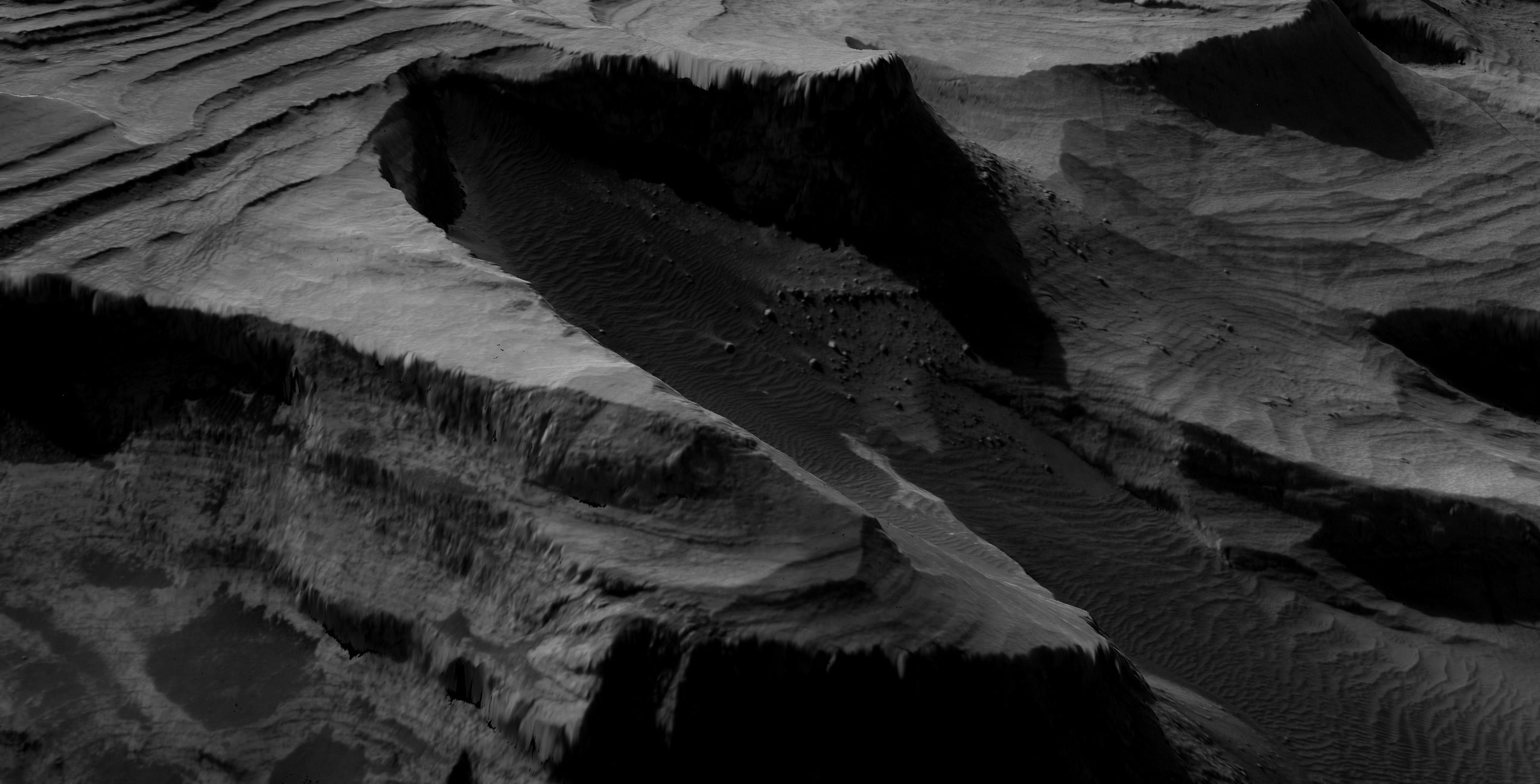
Here's some mars for now (btw I made this elevation model)

Name: Dr. Andrew Annex
Type: User
Company: SETI Institute
Bio: Coder and Planetary Science PhD from Johns Hopkins University. Fmr Postdoc @ Caltech, Current Senior Science Systems Engineer @ SETI Institute
Twitter: AndrewAnnex
Location: Pasadena, CA
Blog: http://andrewannex.com
A GPU based discrete element method (DEM) framework. To cite this software publication: https://www.sciencedirect.com/science/article/pii/S235271101630005X
Blender plugin to generate 3d DTM renders using GDAL.
A simple python wrapper for NASA's SPICE-framework
High level tools for interacting with Spice kernels.
SpiceyPy: a Pythonic Wrapper for the SPICE Toolkit.
A conda-smithy repository for spiceypy.
repo for building python wheels of spiceypy
SPICE Kernels to support SpiceyPy tests
SSYS STAC Extension Specification
A place to submit conda recipes before they become fully fledged conda-forge feedstocks
The NASA Ames Stereo Pipeline is a suite of automated geodesy & stereogrammetry tools designed for processing planetary imagery captured from orbiting and landed robotic explorers on other planets.
Supercharger for mercantile
Surface modelling engine for geological applications
content for geomodeling class
test to see in the setup-minconda with mamba works
Inspect Rasterio/GDAL HEAD/GET/LIST Requests
Time conversion using NAIF CSPICE Toolkit in JavaScript via Emscripten.
Build your own Raster dynamic map tile services
Specification for topography (elevation) quantizers useful for 24bit RGB terrain tile encoding and decoding
ASC TSC (Forked and modified from Node.js TSC)
Technical Steering Committee for the Planetary Software Group
U-Net model for Keras
This repository stores USGS Community Sensor Model (CSM) camera models
VICAR, which stands for Video Image Communication And Retrieval, is a general purpose image processing software system that has been developed since 1966 to digitally process multi-dimensional imaging data.
VIPER Mission Science Software
Main repository for Vispy
Vectorized, pure-Python Perlin noise library
Vombat is a CloudCompare plugin for stratigraphic data extraction and management on Virtual Outcrops
vscode extension to allow viewing of vicar image files
A declarative, efficient, and flexible JavaScript library for building user interfaces.
🖖 Vue.js is a progressive, incrementally-adoptable JavaScript framework for building UI on the web.
TypeScript is a superset of JavaScript that compiles to clean JavaScript output.
An Open Source Machine Learning Framework for Everyone
The Web framework for perfectionists with deadlines.
A PHP framework for web artisans
Bring data to life with SVG, Canvas and HTML. 📊📈🎉
JavaScript (JS) is a lightweight interpreted programming language with first-class functions.
Some thing interesting about web. New door for the world.
A server is a program made to process requests and deliver data to clients.
Machine learning is a way of modeling and interpreting data that allows a piece of software to respond intelligently.
Some thing interesting about visualization, use data art
Some thing interesting about game, make everyone happy.
We are working to build community through open source technology. NB: members must have two-factor auth.
Open source projects and samples from Microsoft.
Google ❤️ Open Source for everyone.
Alibaba Open Source for everyone
Data-Driven Documents codes.
China tencent open source team.