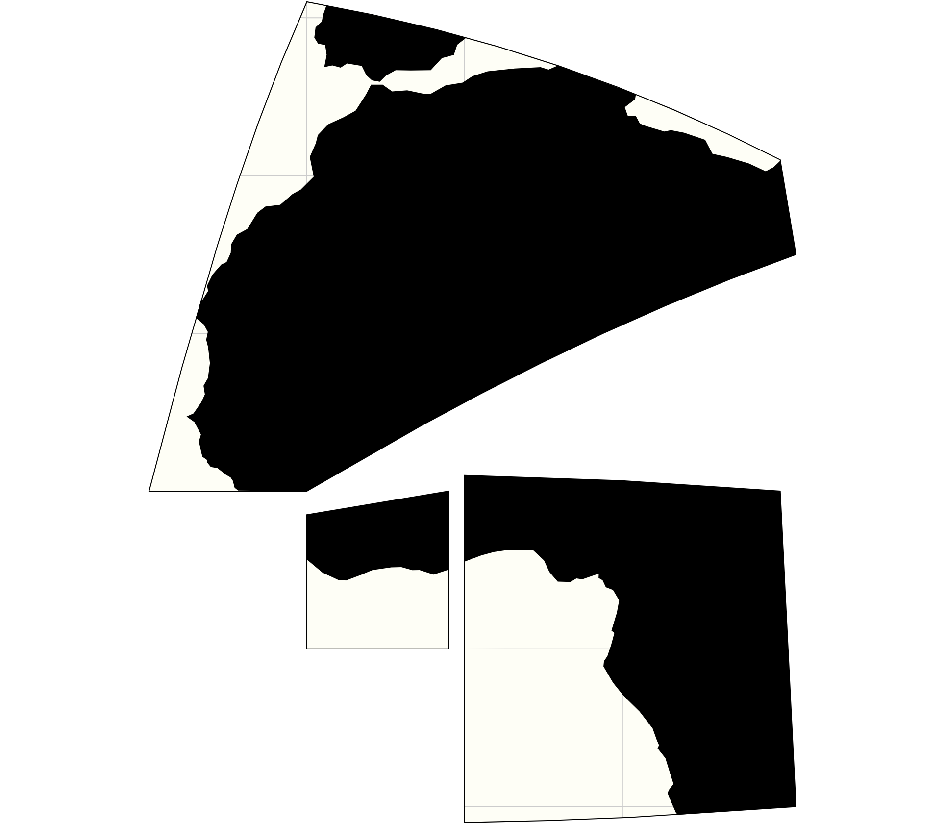
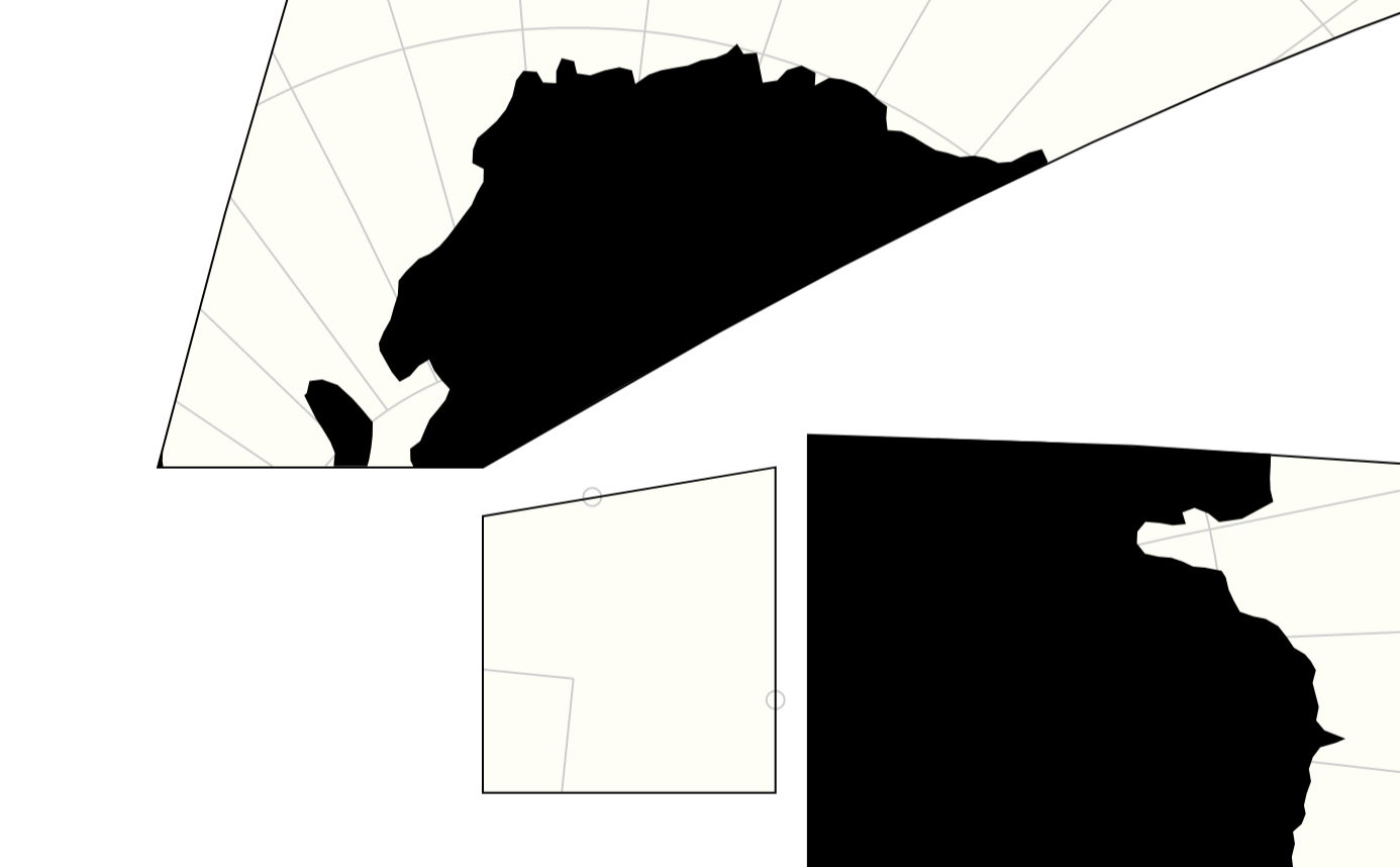
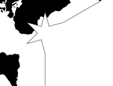
Giter VIP home page Giter VIP logo

d3-geo-polygon's Introduction

D3: Data-Driven Documents

D3 (or D3.js) is a free, open-source JavaScript library for visualizing data. Its low-level approach built on web standards offers unparalleled flexibility in authoring dynamic, data-driven graphics. For more than a decade D3 has powered groundbreaking and award-winning visualizations, become a foundational building block of higher-level chart libraries, and fostered a vibrant community of data practitioners around the world.

Resources

d3-geo-polygon's People

Contributors

biosmanager avatar dependabot[bot] avatar fil avatar goszczynskip avatar mbostock avatar stof avatar

Stargazers

 avatar  avatar  avatar  avatar  avatar  avatar  avatar  avatar  avatar  avatar  avatar  avatar  avatar  avatar  avatar  avatar  avatar  avatar  avatar  avatar  avatar  avatar  avatar  avatar  avatar  avatar  avatar  avatar  avatar  avatar  avatar  avatar  avatar  avatar  avatar  avatar  avatar  avatar  avatar  avatar  avatar  avatar  avatar  avatar  avatar  avatar  avatar  avatar  avatar  avatar  avatar  avatar  avatar  avatar  avatar  avatar  avatar  avatar  avatar  avatar  avatar  avatar  avatar  avatar  avatar  avatar  avatar  avatar  avatar  avatar  avatar  avatar  avatar  avatar  avatar  avatar  avatar  avatar  avatar  avatar  avatar  avatar  avatar  avatar  avatar  avatar  avatar  avatar  avatar  avatar  avatar  avatar  avatar  avatar  avatar  avatar  avatar  avatar  avatar  avatar

Watchers

 avatar  avatar  avatar  avatar  avatar  avatar  avatar  avatar  avatar  avatar  avatar  avatar  avatar  avatar

d3-geo-polygon's Issues

MultiPolygon clipping

The multipolygon branch is a first step towards #9 and #11.

There is a demo here:
https://beta.observablehq.com/d/368627e7d1bcc0cb

each polygon is processed in turn.

multipolygon clipping 1

There are still a few bugs though — as you can see if you rotate the map in the demo, there are sometimes mix-ups in the variables that control the points' visibility, resulting in dots for points that should belong to a polygon, or in full-white surfaces that should be full-black.

capture d ecran 2018-09-12 a 22 26 28

capture d ecran 2018-09-12 a 22 25 58

Can this library be used with other projections?

Namely, d3.geoAlbers? I am trying to use preclipping and am getting very strange results.

More to the point.
Polygon 1:
[ [ [ 30, 60 ], [ 90, 60 ], [ 90, 30 ], [ 30, 30 ], [ 30, 60 ] ] ]
Polygon 2:
[ [ [ 45, 75 ], [ 75, 75 ], [ 75, 15 ], [ 45, 15 ], [ 45, 75 ] ] ]

Projection:
d3.geoAlbers() .rotate([-105, 0]) .center([-10, 65]) .parallels([52, 64]);

Below is a picture made in qGis, cyan polygon (P2) is being clipped, green is the one doing the clipping (P1) (the one passed to geoClipPolygon and the result passed to preclip). Both polygons are already projected (but not preclipped).
intersection

After projecting, P2 is null.

planar polygon clipping

The Imago projection needs to use polygon clipping; but it seems a bit absurd that we are doing spherical clipping (with 200 control points computed as the inverse of 200 planar points) just to do what is in the end a simple rectangular clipping. The thing is tricky because, so close to the limit, the spherical interpolation between control points might jump from one side to the other.

d3.geoVoronoi() is not (yet) existing?

First, thanks for your great contributions regarding projections in D3. I have been playing with your new added projections in this d3-geo-polygon extension in combination with vega. Firstly I used the airocean projection to cut and engrave some wood using laser and liked the result¹.

But now having seen these maps on https://beta.observablehq.com/@fil/speed-of-the-voronoi-projection I would love to play with this projection as well.

I used the method as mentioned in the notebook:

The following map was made with the Voronoi projection — available as d3.geoVoronoi() in d3-geo-polygon.

When I try to use this:
projection = d3.geoVoronoi()

I receive:
TypeError: d3.geoVoronoi is not a function

Question: I'm trying features that are not yet available? or do I call them wrongly?

¹ Click to expand

img_1049
img_1050

Easier usage with d3.geoProject?

It’d be nice if this library were easier to use when saving spherically-clipped GeoJSON. For example:

https://beta.observablehq.com/d/d706c7f9c6e46907

The tedious parts are:

  • You need to wrap the d3.geoClipPolygon instance with an object that has a stream method.

  • You need to compose the d3.geoClipPolygon instance with streams that transform from degrees to radians and then back again.

Part of me wonders if it’s worth revisiting a more composable geographic projection pipeline…

(Also, I think d3.geoProject sometimes breaks polygon semantics, but that’s a separate issue.)

named imports fail in webpack build.

Trying to bundle this in a webpack-based app, I find it breaks because it assumes a hardcoded location for node_modules in many places, eg (from here).

import {abs, degrees, epsilon, radians} from "../../node_modules/d3-geo-projection/src/math";
import {default as matrix, multiply, inverse} from "../../node_modules/d3-geo-projection/src/polyhedral/matrix";

yielding many errors like

ERROR in ./node_modules/d3-geo-polygon/src/polyhedral/waterman.js
Module not found: Error: Can't resolve '../../node_modules/d3-geo-projection/src/math' in '/home/bschmidt/project/node_modules/d3-geo-polygon/src/polyhedral'

Since I'm also requiring d3-geo-projection, these files are not inside the d3-geo-polygon folder: they're located at something like '../../../node_modules', maybe a level higher.

I'm able to get a successful install by just removing the prefix in all javascript files and importing straight from (eg) d3-geo-projection/src/math

~/project/node_modules/d3-geo-polygon/ find . -name "*.js" | xargs -I {} -n 1 perl -pi -e 's/\..\/\..\/node_modules\///g' {}

Can file a pull request if desired, but I don't know if that fix will break in other locations.

Thanks!

Clean up Waterman / Cahill

The issue is described here: d3/d3-geo-projection#125

To sum up this would need to:

  • introduce geoCahill1909 (which would be geoPolyhedralWaterman but with the inferior choice of angles from Cahill's original — and that could be a parameter of course), and be mindful of the face projection used in 1909
  • create a "true" geoWaterman with Antarctica cut out (see also #11)
  • obsolete geoPolyhedralWaterman

faster Voronoi projection

see https://beta.observablehq.com/@fil/speed-of-the-voronoi-projection

The projection is 100x faster if it can use geovoronoi.find() to know to which face a point belongs. In my local branch, I've solved this by allowing to pass a faceFind function.

But should we limit ourselves to this, or be bolder and pass a full geoVoronoi object (which would also help in finding shared edges much faster, by using the delaunay topology)?

Node >10.17.0 support

This package is constrained to node ">=6.0.0 <=10.17.0". Using this package with maintained node versions without ignoring engines constraint isn't possible. Is there any reason why this constraint is present in d3-geo-polygon package.json?

Part of API doesn't seem to rely on node internals eg. geoArcIntersect. Maybe if part of API needs old node version it'll be good idea to move independent code parts into other package.

epsilon3 and intersect(a, b)

From Jason Davies's code (ported in 82d9481#diff-1955ba130f17ffd3f1a5db97ee798e02R13 ), there was an epsilon2 test in this function.

Somehow it allowed lines to escape the clipping on some occasions, so I lowered it to epsilon3 in 202e604 and got much less errors.

But it still happens, and the fix is to get rid of any epsilon and compare the values with 0.

capture d ecran 2018-02-22 a 12 10 13
capture d ecran 2018-02-22 a 12 10 07

I wonder what I'm missing (in which cases this value should be st. positive), but testing in all my examples seems to be OK with 0 instead of epsilon3.

Use clipPolygon for geoInterrupted

example code that works (at least in one test case):

var c = projection.lobes().map(d => d3.merge(d.map(q => {
  var centroid = d3.geoCentroid({type:"MultiPoint", coordinates:q});
  return q.map(p => d3.geoInterpolate(p,centroid)(1e-7)); // pull inside each lobe
})));
c = d3.merge([c[0], c[1].reverse()]); // north, south
projection.preclip(d3.geoClipPolygon({ type: "Polygon", coordinates: [c] }));

capture d ecran 2018-04-19 a 09 31 17

the projection was defined by:

    var lobes = [
      [
        [[-180, 0], [-130, 90], [-95, 0]],
        [[-95, 0], [-30, 90], [55, 0]],
        [[55, 0], [120, 90], [180, 0]]
      ],
      [
        [[-180, 0], [-120, -90], [-60, 0]],
        [[-60, 0], [20, -90], [85, 0]],
        [[85, 0], [140, -90], [180, 0]]
      ]
    ];
    projection = d3.geoInterrupt(d3.geoHomolosineRaw, lobes).rotate([-204, 0])
    .fitExtent([[10, 10], [width-10, height-10]], {type: "Sphere"});

Tetrahedral Lee: Inverse broken?

Hello,

the inverse of the Tetrahedral Lee does not seem to work.
I’ve used the script by @cambeccsee here – to try this. Here is a demo, on top is the Imago projection where the inverse works (everything’s filled with blue pixels) but on the Lee, I only get a red triangle.

Am I doing something wrong or is the inverse broken?

Kind regards,
Tobias

Recommend Projects

  • React photo React

    A declarative, efficient, and flexible JavaScript library for building user interfaces.

  • Vue.js photo Vue.js

    🖖 Vue.js is a progressive, incrementally-adoptable JavaScript framework for building UI on the web.

  • Typescript photo Typescript

    TypeScript is a superset of JavaScript that compiles to clean JavaScript output.

  • TensorFlow photo TensorFlow

    An Open Source Machine Learning Framework for Everyone

  • Django photo Django

    The Web framework for perfectionists with deadlines.

  • D3 photo D3

    Bring data to life with SVG, Canvas and HTML. 📊📈🎉

Recommend Topics

  • javascript

    JavaScript (JS) is a lightweight interpreted programming language with first-class functions.

  • web

    Some thing interesting about web. New door for the world.

  • server

    A server is a program made to process requests and deliver data to clients.

  • Machine learning

    Machine learning is a way of modeling and interpreting data that allows a piece of software to respond intelligently.

  • Game

    Some thing interesting about game, make everyone happy.

Recommend Org

  • Facebook photo Facebook

    We are working to build community through open source technology. NB: members must have two-factor auth.

  • Microsoft photo Microsoft

    Open source projects and samples from Microsoft.

  • Google photo Google

    Google ❤️ Open Source for everyone.

  • D3 photo D3

    Data-Driven Documents codes.