Alpine Peaks is a web app about the peaks of the Alps, using python, django, javascript, and bootstrap. It is my final project of the online course CS50W Web Programming with Python and JavaScript from Harvard / edx.
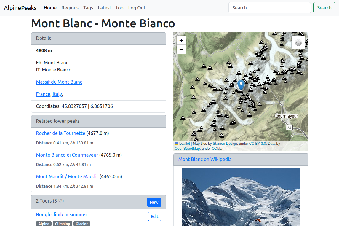
The app shows information about all peaks of the Alps that are higher than 1000 m, including a map and an image and extract from Wikipedia. Users can add their tours with description, grade, tags and waypoints.
-
Django:
- Use a data migration to get data of peaks into the database.
- Use djangos model forms to generate forms and create instances of models.
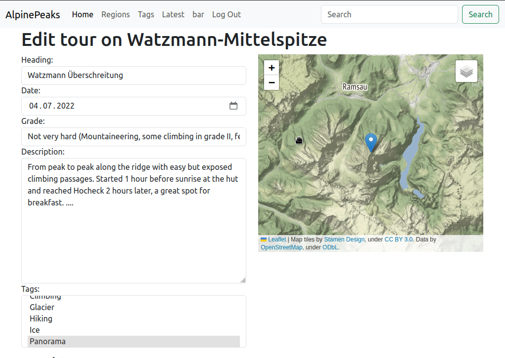
- Dynamically generate forms to add any number of waypoints to a tour using a formset. When editing a tour, initialize the formset with existing waypoints. (Used references: 1, 2, 3, 4 )
- Use slugs for the urls.
- Implement an API that returns coordinates as GeoJSON.
- To get the 3 most dominant peaks of every region for the map, I use a subquery. This is very slow, therefore I implemented ...
- ... caching for the GeoJSON API. The data is not changing anyway.
-
Javascript:
- Get Wikipedia extract and thumbnail image (including image rights) with AJAX from Wikipedia API.
- Use Leaflet to show a map.
- Get peaks and waypoints with AJAX using my GeoJSON API and plot them on the map.
- Implement adding waypoint markers with a click on the map and editing of the coordinates by dragging markers (the numbered marker icons are adapted from this post).
- After learning jQuery I tried to use jQuery as much as possible.
-
Data:
- I used python and geopandas to clean and enrich the raw data originally downloaded from OpenStreetMap.
- django (tested with django 4.1.5)
- Download peak data, see next section
- Install Django
- cd into the directory of the app (containing manage.py)
- Download peak data with:
wget https://www.dropbox.com/s/gk055ofbfswigwj/alps.geojson?dl=0 -O alps.geojson
- Create database and load initial data into database with:
python manage.py makemigrations
python manage.py migrate
- You can now remove alps.geojson:
rm alps.geojson
- Start app/webserver with:
python manage.py runserver
The app requires data of the peaks of the Alps that must be downloaded into the working directory (see Run the Application above) before running the app for the first time.
The peak data is © OpenStreetMap and Florian Neukirchen under Open Database License.
The data was originally downloaded in QGIS using the QuickOSM plugin (search for natural=peak). It was preprocessed in a Jupyter Notebook (alpine_peaks.ipynb on GitHub) with python and geopandas. In QGIS I added the nearest higher peak with my QGIS plugin nearest greater – I wrote this plugin in the last months.
Contains the models used by the app:
- User
- Peak
- Contains all the data extracted from OpenStreetMap including coordinates, elevation, names in different languages, etc.)
- The function
geojson()returns the peak as GeoJSON feature. - The property
likesreturns the sum of all likes of tours to the peak. - Relation to the models Country, Region, Tour.
- Country
- Region
- Tour
- Users can post tours to any peak; with heading, description, grade, date, tags, and waypoints.
- Tours can be liked by other users.
- Waypoint
- Tours can have waypoints (with latitude, longitude and optional name).
- The function
geojson()returns the waypoint as GeoJSON feature.
- Tag (for Tours)
- Grade (for Tours)
Contains the forms used by the app:
- OrderSelect (used to select the order on the index view)
- WaypointForm (model form based on Waypoint model, used in WaypointFormset)
- WaypointFormset (formset used in the view for editing/creating tours)
- TourForm (model form based on Tour model, used in the view for editing/creating tours)
This file is the data migration to load the peaks data into the database. It will fail if the file alps.geojson does not exist. As already mentioned, you have to download the file first with:
wget https://www.dropbox.com/s/gk055ofbfswigwj/alps.geojson?dl=0 -O alps.geojson
The data migration reads the peaks data as json and saves it to the database.
Another data migration to add some tags and grades (of mountain tours) to the database.
The view functions used by the app. The most important views are:
- index()
- lists peaks using pagination
- used for:
- the main route, listing all peaks of the alps
- the region and country routes (url with slug)
- search (with a GET request with
?q=<searchstring>)
- peak()
- Show detailed information of a peak
- List tours using pagination
- tour()
- Create new tours, edit tours, delete tours, like tours.
- Login required
- A GET request renders the form
- ... for a new tour, if the peak id is passed with
?new=<peakid> - ... to edit an existing tour for urls like
edit/<tourid>
- ... for a new tour, if the peak id is passed with
- A POST request saves the data from the form to the database.
- A DELETE request deletes a tour.
- A PUT request is used to like a tour.
- Uses the form TourForm and the formset WaypointFormset
- showtour()
- Show the details of a tour
- profile()
- Show user profile
- List tours using pagination
- jsonapi()
- Returns peaks as GeoJSON features
- Used with AJAX to plot peaks on the map
- With slug: all peaks of a region
- Without slug: The 3 most dominant peaks of each region (the algorithm uses a subquery and is very slow)
- Uses caching
- waypoints()
- Returns waypoints of a tour as GeoJSON to plot them on the map using AJAX.
- likes()
- Update the likes of a tour after toggling the like.
- tag()
- List tours with a given tag using pagination.
- tags()
- List all tags.
- regionlist()
- List all regions and countries.
- layout.html (base layout used by all templates)
- index.html (used by index view)
- peak.html (used by peak view)
- tour.html (used by tour view to edit/create tours)
- showtour.html (used by showtour view)
- tourlist.html (used by showtour view to list recent tours)
- profile.html (used by profile and tags views)
- regions.html (used by regionlist view)
- (login.html and register.html are adapted from the problem sets).
- Leaflet Map:
- Show map with 2 different base maps.
- Get peaks of mountain region with AJAX from my GeoJSON API and add them to the map as GeoJSON layer.
- Same for dominant peaks of the Alps (3 prominent peaks for every regions).
- Add tooltips and click events for these peak markers.
- Tour view: Get existing waypoints with AJAX from my GeoJSON API and add them to the map as GeoJSON layer.
- Edit waypoints:
- Add waypoints by clicking on the map.
- This dynamically adds a form within the waypoints formset.
- Waypoint markers can be dragged to a new position, the coordinates are updated in the form.
- Allow to delete the last waypoint.
- Wikipedia API (with AJAX):
- Search for Wikipedia article with the name of the peak.
- Get the main image of the article, including image rights.
- Get an extract of the article.
- Handle click events etc.:
- Toggle likes,
- changes of the "order by" dropdown reload the page accordingly,
- activate tooltips (used for tour grades),
- delete tour with DELETE request.
- /peaks/urls.py (definition of url patterns)
- /static/peaks/peaks.css (custom css in addition to bootstrap)
- Icons:
- favicon.ico
- mountain.svg (marker icon on maps)
- mountain-grey.svg (marker icon on maps)
- wpmarker.png (marker icon for waypoints on maps)
For minor peaks, the article and image fetched from Wikipedia may not at all be related to the peak.
