Giter VIP home page Giter VIP logo

metro-map-maker's Introduction

Metro Map Maker

Build the Metro system of your dreams: create your own metro maps, save them, and share with friends!

Features

  • Draw new rail lines and stations
  • Autosaves after making changes
  • Download your finished map as an SVG or PNG image
  • Create a new map, or remix an existing map
  • Choose from 5 different line widths and 28 station styles -- and change them in 1 click
  • Remix any of the 200,000 maps (and counting) in the library and make it your own
  • Get a unique URL to share your map with friends! Don't worry -- when they remix your map, you won't lose your original!

Gallery

Here are some of my favorite maps created by MetroMapMaker.com visitors like you: https://metromapmaker.com/gallery/

All Maps Ever

Browse all of the 200,000 maps (and counting) in the library: https://metromapmaker.com/calendar/

Made something cool?

I'd love to see it! Say hi!

Love Metro Map Maker? Let me know!

Have an idea for how to make Metro Map Maker better? Tell me about it!

Found a bug in Metro Map Maker? Let me know about it!

ko-fi

Check it out

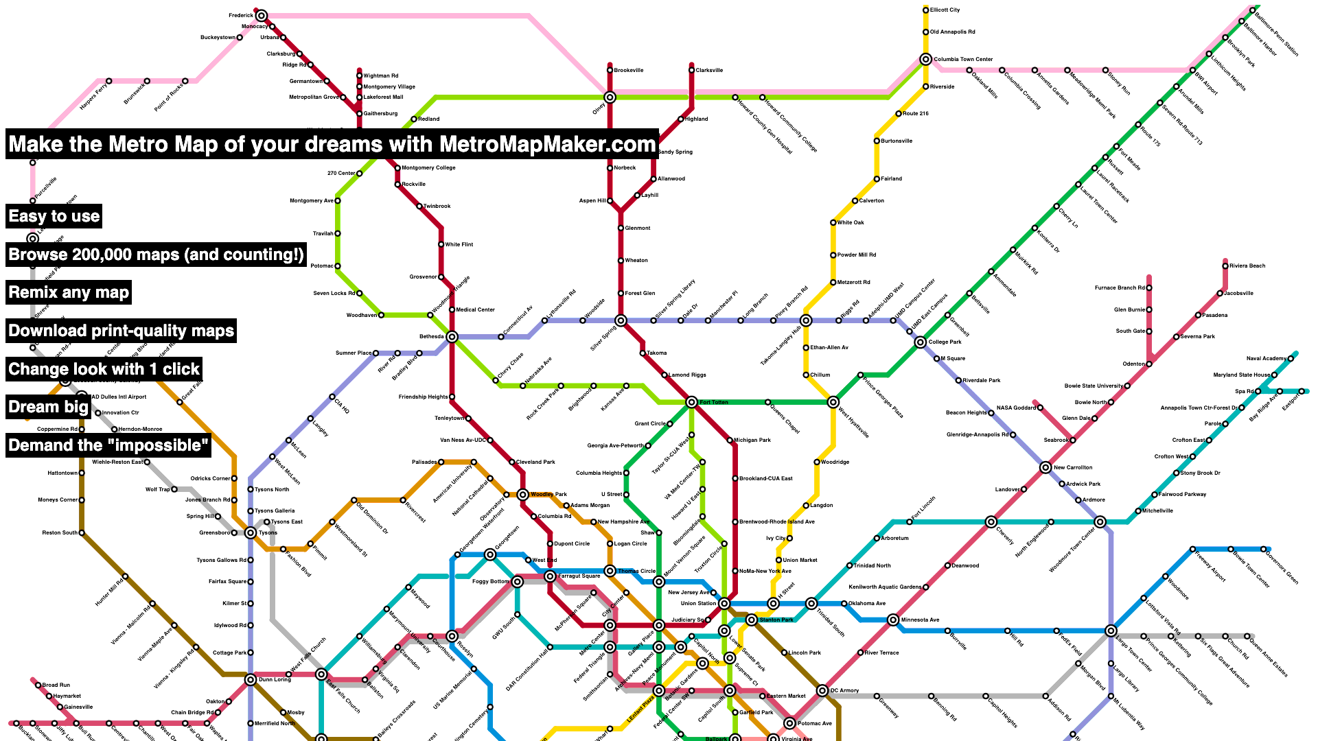
This metro map was made with https://metromapmaker.com:

alt text

metro-map-maker's People

Contributors

shannonturner avatar

Stargazers

 avatar  avatar  avatar  avatar  avatar  avatar  avatar  avatar  avatar  avatar  avatar  avatar  avatar  avatar  avatar  avatar  avatar  avatar  avatar  avatar  avatar  avatar  avatar  avatar  avatar  avatar  avatar  avatar  avatar  avatar  avatar  avatar  avatar  avatar  avatar  avatar  avatar  avatar  avatar  avatar  avatar  avatar  avatar  avatar  avatar  avatar  avatar  avatar  avatar  avatar  avatar  avatar  avatar

Watchers

 avatar  avatar  avatar

metro-map-maker's Issues

Feature Request: Add redo

Being able to undo is useful, but being able to redo if you undo too far would also be useful.

While here, undo and redo should maybe get their own buttons?

Feature Request: Add "stickers" or symbols (other than emoji, which are currently supported)

Right now you can add emoji to a station name, but what if there was a bank of "stickers" or symbols that could be added?

These could be added to the canvas via .drawImage() (https://developer.mozilla.org/en-US/docs/Web/API/CanvasRenderingContext2D/drawImage), and inclusion in SVGs would be trivial (assuming the stickers/symbols were SVGs as well).

These could be especially useful for insets, legends, the Metro "M", etc.

Admin: Show all maps

Currently my process to view newly-created maps is slower than I would like.

I would like to create a new admin page that lets me view canvas images of every map saved with the Save & Share Map feature.

Feature Request: Reduce overlap on adjacent lines of different colors

From Youtube:

When two or more lines are drawn on top of each other, (Example: Using the fill tool to make water) it creates this weird lumpy effect on the lines. Not a huge big deal, but it can definitely make the map look a bit weird, or unintentionally displeasing to look at. If you change make it so that the lines didn’t look lumpy when over lapping each other in the update, that’d be great!

This is especially noticeable when using flood fill.

First, there's a purple line:

Screen Shot 2024-04-14 at 3 40 35 PM

After flood fill, it's very difficult to see at all:

Screen Shot 2024-04-14 at 3 40 44 PM

Reducing the line width to 12.5% makes it clearer what's happening here:

Screen Shot 2024-04-14 at 3 41 13 PM

Here, you can see that the water is connecting across the purple line.

Admin: Modernize admin gallery

The admin gallery needs an update, it's only barely v6 compatible and has a lot of newly-unused code than can be deleted.

While here, should probably change how the public gallery is generated. Will open a separate issue.

Offer pre-made color palettes that look nice together

Some color choices look visually very nice together; it might be helpful to offer a handful of different options to choose from or quickly add to your map.

There's already some precedent for this, since the WMATA colors are offered if you don't have any.

Feature Request: Set background color without flood fill

Right now maps have a transparent background which displays as white during editing.

You could flood fill to get a different color if you wanted, but being able to set a background color instead would make maps load a lot faster.

From Youtube:

Nice update! Can you make an option to change the background to any color? It would be more convenient than having to use the fill tool and select a color on the draw rail line thing.

Set WMATA Metro as the default map

Rather than showing a blank slate, it might be more intuitive if the default map were the Metro.

(But only for first-time visitors with no localstorage / not using a loaded MapURL)

Question: format of the map?

Hi,
I would like to programmatically create a map and generate the image offline.
Do you think it's possible?
I know Python but not Django and I have difficulty to found where the map format is implemented.
Any guidance?
Thanks

Feature Request: Remove the anti-aliasing "eraser marks"

The "eraser marks" you see when you draw a line and then erase it are because erasing works by drawing an equally-sized white line or circle above the existing color. This is especially noticeable when zoomed in by a lot.

I quite like the charming look of the eraser marks, and they'll go away on the next call to drawCanvas(), but I could probably either call drawCanvas() more often than I do now that it's so much faster than before, or find another way to handle erasing.

From Youtube:

When you start drawing lines, for some reason there this weird effect where there’s these thin little white semi circle outlines along the line. It’s hard to see and you might not notice it, but if you look closely it’s not hard to see. Also, when you use the eraser tool to erase a line, there’s this weird ghost effect where there’s a thin outline of where the line used to be. There also a weird effect when lines are drawn on top of lines. It’s this weird bumpy unsmooth effect when they’re place on top of each other. All of these things make it a bit difficult to see how the final map is going to be without having to export, or reload it every time.

Add highest-rated maps view

This can wait until after users have rated (liked, disliked) maps for a while, but I'm really curious to see what the highest-rated maps are, and I think others would be interested too!

Probably will link to this in the top navbar and from /gallery/

Dark Mode

For all the night owls making maps into the small hours, add a toggleable option.

Best if it applies site-wide, including on the calendar and gallery.

Feature Request: Flood fill line width/style, not just color

When maps can mix and match line widths (dependent on #30) and/or styles (dependent on #31), it may be useful to be able to have flood fill also change the line widths and/or styles.

(By default, flood fill would likely only set flood-filled portion to the active color.)

This might get confusing quickly, and it might be good to have multiple modes, though this would require a lot of options. Worth thinking through this carefully and identifying the simplest implementation.

Matching Options:

  • Flood fill matches on color regardless of line width or style
  • Flood fill matches ONLY on matching color, line width, and style
  • Flood fill matches ONLY on matching color and line width, but doesn't match when style is different

Fill Options:

  • Flood fill sets color only
  • Flood fill sets color, line width, and style
  • Flood fill sets color and line width, but not style

Feature Request: Increase maximum map size

Frequently-requested feature on both reddit and youtube has been to increase the maximum map size.

The main constraints:

  • Maps should load very fast, even when very large or with a lot of detail (especially important on mobile or rate-limited connections)
  • Safari may have hard limitations on the canvas size
  • Maps should look crisp, not blurry, when editing
Size Grid Squares
80 6,400
120 14,400
160 25,600
200 40,000
240 57,600
320 102,400
360 129,600
480 230,400
640 409,600
Compared to: 80 120 160 200 240 320 360 480 640
80 1 0.44 0.25 0.16 0.11 0.06 0.05 0.03 0.02
120 2.25 1 0.56 0.36 0.25 0.14 0.11 0.06 0.04
160 4 1.78 1 0.64 0.44 0.25 0.20 0.11 0.06
200 6.25 2.78 1.56 1 0.69 0.39 0.31 0.17 0.10
240 9 4 2.25 1.44 1 0.56 0.44 0.25 0.14
320 16 7.11 4 2.56 1.78 1 0.79 0.44 0.25
360 20.25 9 5.06 3.24 2.25 1.27 1 0.56 0.32
480 36 16 9 5.76 4 2.25 1.78 1 0.56
640 64 28.44 16 10.24 7.11 4 3.16 1.78 1

Feature Request: Station labels above, below (not rotated)

Currently, the station orientations Above 90º and Below 90º exist, but having labels appearing above or below a station without any rotation has also been requested.

Centering seems like the only snag, though in JS this seems fairly easy since I can .measureText(); I'll have to see if there's a similar option for SVG.

Feature Request

  • integration with OpenStreetMap
  • Ability to change opacity and pattern of lines
  • arrow keys to scroll instead of moving map
  • ability to select space between stations and enter real life distance and scale it

Feature Request: Add free text (or: "hidden" station marker style)

Some users have requested the ability to add free text onto a map, without a station involved.

Probably the easiest way to add this without major changes to the data model or rendering engine would bet o create a new station style that has no rendered appearance and only displays the text. The main challenge here would be in displauing/selecting the hidden stations, or having them clickable while not rendering them during editing.

A more complex implementation would add true free text as an option. Worth considering which option is better, because I probably won't add both!

If you're here and would like to vote:
🎉 : Use the existing stations to add free text, just add an option to make the station marker hidden
❤️ : Add a free text button that isn't part of the stations

Find similar maps (Gallery View)

With a single given map:
Calculate levenstein or other similarity score to all other maps
Show most similar maps on a single page

This could be useful as an enhancement to the existing Gallery View. Sometimes similar maps are distributed across several pages, which makes it difficult to know which one(s) to hide.

Feature Request: Additional font options

As requested on Youtube, it would be nice to have a bank of additional fonts besides the default Helvetica.

Note that any additional fonts should be widely-accessible and preferably have a useful fallback.

I'll also need to figure out whether this has any impact on my SVG maps, or the PNG maps generated from the SVGs.

Feature Request: Mix and match line widths

A frequently-requested feature on both reddit and youtube is to be able to mix and match line widths similar to how you can mix and match station styles.

This would have the benefit of allowing all 28 possible station shapes to be used within the same map, and give a great deal of flexibility to map styles.

Expand the available grid sizes

Expanding the available grid size would allow larger maps to be created and cities like NYC and Chicago to have maps of their metro systems.

While adding more squares to the grid is trivial, careful attention will need to be paid to the validator script and most importantly to the grid-to-canvas-image converter.

The current (original) size of the grid is 80x80 (6400 squares)

I think maybe creating a Resize Grid button / feature would be good to do.

The Resize Grid button should expand with options when clicked, and have an option to hide the Resize options. It should have a warning like "Careful: if you resize a larger map onto a smaller grid, you'll lose your work!" similar to how I warn on the "Move map" feature.

Sizes that I think might make sense include:

  • 80x80 Small (6400 squares)
  • 120x120 Medium (14,400 squares, 2.25 times larger than original)
  • 160x160 Large (25,600 squares, 4 times larger than original)
  • 200x200 Extra Large (40,000 squares, 6.25 times larger than original)

Maybe extra large is overkill, but I wonder what people might do with all that extra space?

Click and drag on eraser or line doesn't fill first cell

Clicking and dragging fills (or erases) all cells except the first one. Reproduce: drag orange line from (1,1) to (1,4). Only (1,2), (1,3), (1,4) are filled. Expected behavior is inclusive filling, i.e. also fill the starting cell (1,1).

Feature request: Background image in editor

Being able to set an image of the city you want to design a map for would probably make it easier to get an approximate layout for the plan done. To avoid copyright stuff (and since it wouldn't fit with the idea of the metro plan anyway) it would just need to be there in the editing phase and not in the export.

Add "Similar Maps" to Rating view

The admin view "Similar Maps" is really useful, and it would be nice to add this as an option to the rating view to see whether there are other versions of the same map.

Important: before I release this more broadly, I'd need to significantly improve the performance of this view.

Feature Request: Search maps by city

From email:

Can there be a feature where I can search up a map name? For example, if I want to search up “Minecraft”, all maps labeled Minecraft will pop up.

Rectangle station marker overlaps with its previous version until the next call to `drawCanvas()`

If a singleton square station is replaced with a non-singleton square station (which is smaller), there's an overlap until the next drawCanvas() call:

singleton-square-replaced

One potential solution would be to check for a station in the neighboring 8 points of the just-drawn point; if so, call drawCanvas() for stations only.

Depending on how I address #46, that may address this too.

To reproduce:

  • Make a singleton point, then add a square station and notice that the station is a square
  • Connect lines to that point, then notice that the station marker shrinks, but the older square station marker from step 1 is still visible
  • Change the direction that the rectangle station marker should be drawn by drawing more lines and notice that the overlap occurs again, in a diagonal direction

Map Diff

When reviewing maps in the gallery, it can be difficult to tell similar maps apart especially when the changes are small.

Was it just a new station added? Or a change in the orientation of a station label?

Or were the changes more sweeping?

Which version of a similar map should be kept? It's probably a safe assumption that the most recent version should be kept, but I should make sure.

A Map Diff feature in the gallery would help with this.

SVG animation: see how maps have changed over time

I'd be so curious to see how maps have evolved over time -- maybe I can put together a way to animate two or more SVGs to see the progression of a metro system?

I bet this would be really cool looking!

Better support for mobile (touch)

It seems to me like trying to make a metro map on mobile / tablet would be pretty time-consuming and potentially annoying compared to on desktop (especially since it would be hard to see the finished product in total), but maybe there's demand for it?

Explore whether it's easy to add better support for mobile. Sam in #13 correctly identified the problem is that the drawing features expect a single touch, so clicking and dragging doesn't translate well to mobile.

Gallery: Consider other loading strategies besides base64 encoded/compressed

Currently, the public gallery loads a lot of <img> tags with base64-encoded maps.

This caches and compresses well, so it loads extremely quickly even though it's not the most obvious implementation.

With .png and .svg thumbnails being stored on disk, it may be worth exploring alternative loading strategies like lazy loading images.

Related to #55

Add tests for the validator script

Adding several validator tests for valid and invalid map json blobs will help me feel more confident that I'm not introducing new bugs when I expand available grid sizes

Feature Request: "Notch" or "Line" station style

Kinda similar to the London style; distinguishable from the current "Rectangle" style by not always being centered / possibly adapting based on the line direction and/or the station orientation.

Would want to figure out the specifics here first; the main drawback of the London style is that the station markers are fairly small.

London-style also requested on reddit.

Calendar: Consider sorting maps by most likes (on day view)

Right now, maps at /calendar/2024/04/14/ are displayed from newest to oldest, but maps created early in the day won't be seen as readily due to pagination.

If performant, consider removing the pagination (or raising the limit to be higher).

Alternatively, consider sorting by maps with the most likes.

This may help highlight the most advanced version of a map when a day has multiple versions of a map in progress, but doesn't help much if a map is created over multiple days.

100 Most Popular Colors

Kind of a weird feature but I'm kinda curious: what are the most popular user-chosen colors?

Maybe this would be a good offering for #41.

Feature Request: Font Sizes for Station Text

Having different font sizes for station text, including being able to mix and match sizes.

For instance, being able to display station names in the primary and secondary languages.

From Youtube:

I would love a feature that allowed us to be able to manually split into lines very long several-word names like "Vichuquen Huapí–Western Terminal" so it does not take so much space it end up clashing with other names no matter in which direction you put it if the station is in a very transit dense area. I also think public transit maps should reflect their users and part of that is multilingual station names, and so I would like a feature that allows for the display of secondary names (to write in romanizations or translations underneath, so I can, for example, put Hospital General under 病院一般 instead of it all being on a single line)

Feature Request: Measure line

From Youtube:

As someone who has been obsessed with making maps in your site the past three months, it's very exciting to see the new changes! Just a suggestion: Is it possible to add a measure line feature? The only downside for me is having to count the squares so everything is well distributed :p

Thematically feels related to #34, and maybe will be part of the select feature, telling you how many squares you get w/h.

A hyphen in the short URL breaks the DIFF button?

When trying to calculate the diff for fZiw-kEA, clicking the diff button only adds "fZiw" to the input text field.

Since the full URL hash isn't in the text field, a map's diff can't be calculated. See attached screenshot.

fziw-kea

Feature Request: Consider a login system

From Youtube:

Hello! I have been using metro map maker for so long now and it's been really cool because it brings my head cannon into reality! The line width adjustability is SO COOL and I literally jumped in excitement (not even joking). I currently have 3 huge metro systems and they look kind of plain. This new update will bring SO MUCH MORE. I cannot express how excited I am. I know this is really hard to do, but for a suggestion in the future, you can make a google doc like system, where there is a home screen that contains all of the saved maps on your account (which is the hard part), and then it would be so convenient. I know this is difficult so if that's not possible, I don't care, this website is already INSANE as it is. KEEP UP THE GOOD WORK!!!!

Some of my thoughts about a potential login system are detailed at https://metromapmaker.com/help/#faqs-autosave, but the most important idea here should be that a login system should be 100% optional and you should be able to create maps without a login.

I think being able to save maps whether or not you made them yourself seems useful and in line with this request.

Recommend Projects

  • React photo React

    A declarative, efficient, and flexible JavaScript library for building user interfaces.

  • Vue.js photo Vue.js

    🖖 Vue.js is a progressive, incrementally-adoptable JavaScript framework for building UI on the web.

  • Typescript photo Typescript

    TypeScript is a superset of JavaScript that compiles to clean JavaScript output.

  • TensorFlow photo TensorFlow

    An Open Source Machine Learning Framework for Everyone

  • Django photo Django

    The Web framework for perfectionists with deadlines.

  • D3 photo D3

    Bring data to life with SVG, Canvas and HTML. 📊📈🎉

Recommend Topics

  • javascript

    JavaScript (JS) is a lightweight interpreted programming language with first-class functions.

  • web

    Some thing interesting about web. New door for the world.

  • server

    A server is a program made to process requests and deliver data to clients.

  • Machine learning

    Machine learning is a way of modeling and interpreting data that allows a piece of software to respond intelligently.

  • Game

    Some thing interesting about game, make everyone happy.

Recommend Org

  • Facebook photo Facebook

    We are working to build community through open source technology. NB: members must have two-factor auth.

  • Microsoft photo Microsoft

    Open source projects and samples from Microsoft.

  • Google photo Google

    Google ❤️ Open Source for everyone.

  • D3 photo D3

    Data-Driven Documents codes.